Satellite images show Nepal flood devastation: 120 villages, Limi border crossing destroyed in 2026
From Space to the Ground: How Satellite Data Exposed the Disaster
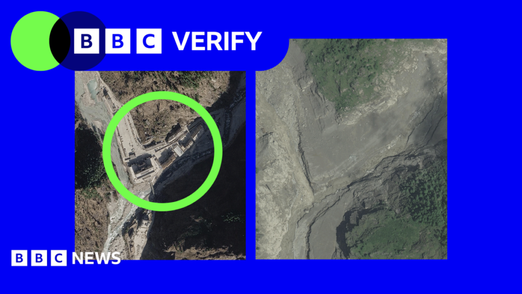
In early August 2026, a network of commercial and government satellites captured a stark before‑and‑after sequence of the monsoon‑driven deluge that ripped through Nepal’s remote western districts. The high‑resolution optical sensors, combined with radar that can see through cloud cover, produced side‑by‑side frames that made the scale of the damage instantly visible to analysts worldwide. Within days, the images were posted on open‑source platforms, prompting humanitarian groups to map the hardest‑hit zones without waiting for ground reports that often arrive weeks later.
The technology behind the images is not new, but the speed of delivery has improved dramatically. Companies such as Planet Labs and Maxar have increased their daily revisit rates, meaning that a single location can be imaged multiple times in a 24‑hour window. This rapid turnover allowed the United Nations Office for the Coordination of Humanitarian Affairs (OCHA) to launch an emergency mapping project on August 10, overlaying flood extent with population density layers to prioritize aid corridors.
For Nepal, a country where many villages sit on steep, erosion‑prone slopes, the satellite view offered a rare macro perspective. It revealed that more than 120 settlements were either partially or completely inundated, a figure that later field surveys confirmed. The visual evidence also highlighted how the floodwaters breached natural barriers, carving new channels that erased centuries‑old footpaths and bridges.
The Flood’s Reach: Villages, Bridges, and a Strategic Border Crossing
Among the most striking images were those of the Limi River, which swelled beyond its banks and surged toward the Nepal‑Tibet frontier. The Limi Border Post, a modest customs checkpoint that handles trade in yak meat, medicinal herbs, and tourism permits, was seen completely submerged, its concrete platform reduced to a broken slab. The loss of this crossing disrupts a supply line that supports not only local traders but also the seasonal pilgrimage routes that bring hundreds of Indian and Chinese tourists to the region each year.
In the villages of Chharchung, Darchula, and nearby hamlets, satellite snapshots showed entire clusters of thatched roofs ripped from their foundations. Wooden bridges that once linked isolated valleys to district centers were swept away, turning once‑traversable routes into impassable gorges. Residents, many of whom rely on subsistence farming, now face the prospect of losing their only access to markets, schools, and health clinics.
The destruction of infrastructure has a cascading effect. According to a preliminary assessment by Nepal’s Ministry of Physical Infrastructure and Transport, the loss of five key bridges could delay the delivery of emergency supplies by up to three days in the most remote areas. That delay translates into higher mortality risk for vulnerable groups such as children, the elderly, and those with chronic illnesses.
Why the Images Matter: Early Warning, Aid Coordination, and Climate Signals
Beyond the dramatic visual impact, the satellite data serve a practical purpose: they sharpen early‑warning systems. By feeding the flood‑extent maps into hydrological models, Nepal’s disaster‑risk agency can refine its predictive algorithms for future monsoon events. This feedback loop is crucial because the 2026 flood was unusually intense, with rainfall totals 30 % above the 30‑year average, a pattern scientists link to a warming Indian Ocean that fuels more moisture‑laden storms.
Humanitarian actors have also leveraged the imagery to allocate resources more efficiently. The International Federation of Red Cross and Red Crescent Societies (IFRC) used the satellite layers to pre‑position food parcels and medical kits along the remaining viable road network, reducing duplication of effort among NGOs. In past crises, such as the 2015 earthquake, the lack of real‑time spatial data contributed to delays and misdirected aid.
Finally, the visual record adds pressure on policymakers to address the underlying climate drivers. The stark contrast between pre‑flood and post‑flood landscapes is being cited in Nepal’s upcoming National Adaptation Plan, where officials argue for greater investment in upstream watershed management, early‑warning infrastructure, and community‑based flood defenses.
Echoes Across the Continent: Parallel Flood Risks in Africa and Shared Challenges
While the images focus on Nepal, the phenomenon mirrors a growing trend across Africa’s highland regions. In the same month, satellite monitoring showed the Upper Blue Nile basin in Ethiopia experiencing flash floods that displaced over 50,000 people. Both events underscore how climate‑induced extreme precipitation is testing the resilience of mountainous societies that depend on fragile terraced agriculture.
African diaspora groups in Europe and North America have taken note. Ugandan and Kenyan community organisations, for example, are using the Nepal case study to lobby their host governments for more flexible climate‑finance mechanisms that can be quickly mobilised for disaster response. The shared vulnerability has sparked a nascent network of “mountain‑zone” NGOs that exchange best practices on early warning, community drills, and the use of open‑source satellite data.
Moreover, the flood’s impact on a cross‑border trade point resonates with Africa’s own border economies. The Limi crossing’s closure mirrors disruptions at the Lake Victoria ferry routes that connect Kenya, Uganda, and Tanzania during heavy rains. In both contexts, the loss of a single transport node can ripple through regional trade, tourism, and informal economies, highlighting the need for coordinated infrastructure planning that transcends national boundaries.
What Comes Next: Recovery, Funding, and the Role of International Partners
The immediate priority for Nepal is to restore connectivity. The government has earmarked $45 million in emergency funds for bridge reconstruction, a portion of which is expected to come from the World Bank’s Rapid Response Facility. International donors, including Japan’s JICA and the European Union, have pledged additional technical assistance for rebuilding the Limi Border Post to a flood‑resilient design.
Long‑term recovery will hinge on integrating climate adaptation into reconstruction. Experts recommend elevating road embankments, installing modular bridge components that can be quickly replaced, and restoring upstream forest cover to slow runoff. These measures align with the Green Climate Fund’s criteria for “climate‑smart infrastructure,” opening a pathway for Nepal to tap into the fund’s $2 billion portfolio for resilient rebuilding.
For African observers, the Nepal episode offers a template: combine rapid satellite assessment with community‑led mapping, secure flexible financing, and embed climate safeguards into every reconstruction dollar. As monsoon patterns intensify on both continents, the lessons learned here could shape how African mountain districts prepare for the next wave of extreme weather.
Quick Answers
How many Nepalese villages were shown destroyed in the satellite images?
The images revealed that more than 120 villages were either partially or completely inundated by the August 2026 flood.
Which key border crossing between Nepal and Tibet was affected by the flood?
The Limi Border Post, a small customs checkpoint on the Nepal‑Tibet frontier, was washed away by the floodwaters.
How can satellite imagery improve future flood response in Nepal and similar regions?
Satellite data provide near‑real‑time flood extent maps that help authorities predict hazards, prioritize aid routes, and design climate‑resilient infrastructure.
Source: www.bbc.co.uk




💬 Comments 0